Life, Technology, and Meteorology

Category: Weather (Page 2 of 2)

Northwest Storm

James Duncan Davidson writes:

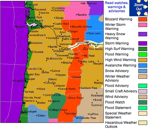
Here in the Pacific Northwest, we’re prepping for a big storm that’s set to rip through tonight. Hurricane force winds are forecast on the coast, blizzard conditions are forecast for the Cascades, and it looks like we’re going to get rattled about here in Portland. Already, the winds are gusting about and hitting 40mph.

I just caught wind (no pun intended) of this storm earlier this afternoon. There are storm warnings covering the entire coastline of Washington and Oregon, and even part of Northern California, this is definitely going to be a big one. I even saw a High Surf Warning with estimated swell heights of 38-42 feet. If you’re in that area, hunker down and stay safe.

Seasonality 1.4

I released Seasonality 1.4 out into the wild this morning. So far the release is going pretty nicely, without any major bugs found as of yet. I’ve been using the beta for the past few months without finding any major issues, so I kind of expected this to be a pretty stable release. The forecast server here has dished out over 700,000 forecasts up through yesterday (that’s without a final Seasonality release hitting it). I’m interested to see how long it will take to hit a million with this official release of version 1.4. Thanks go out to everyone who helped beta test this release.

Also, with the risk of writing about out-of-date news, I’ve posted a couple of weather articles over on the Gaucho Software Forums. First is an explanation for the fairly quiet Atlantic hurricane season this past year. I talk about some of the ingredients needed to form a hurricane, and what has been missing this year. The second article, posted last week, explains why why relative humidity is a bad measure of moisture in the atmosphere. If you’re interested in either of those topics, be sure to check out these articles. As a side note, I am patiently waiting for the next release of YaBB Forum software, which has RSS support so users will be able to subscribe to these weather articles I post. They have a feature-lock on the release, but no word yet on an expected release date.

Midwest Snow Storm

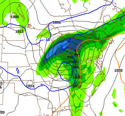
If you live in the Midwest, either you are getting hit with this storm right now or you will be getting hit with it soon. This storm has the potential to be the first big snow for the year in many areas. The forecast models have been all over the board with predicting this event. At least, that was the case up until earlier today when the 0Z and 12Z runs of the GFS and NAM, along with some other models are now much more agreeable with this storm’s track. When the models line up, that’s a pretty good sign of an accurate path.


The image below shows the precipitation forecast for Friday between 12 and 18Z (7am – 1pm EST). Right now, this system is starting to form in Texas. The storm will be traveling NNE over the next 36 hours to around Ohio in the time period of the image below. The precipitation “arrow” is pretty much pointing in the direction this thing is moving. The lightest blue is between 0.75 and 1 inch of liquid equivalent precipitation… However, if you follow the deep blue line marked 0 degrees C, all of this area will be getting either a rain/snow mix or all snow. 1 inch of liquid precipitation can equate to anywhere between 6-10 inches of snow depending on the temperature. Since this image just shows the precipitation for a 6 hour time period (and not the entire storm’s precipitation), there is a real potential of a bunch of snow being dumped along it’s path. Some models have forecasted up to 17 inches here in central Michigan, but I think that’s really overshooting it. I’m guessing it will drop around 6-8 inches of heavy snow for our area, and definitely more in some other areas.

Anyway, here’s hoping we’ll get enough snow to go sledding this weekend. 🙂
Buffalo Snow Storm

I just wrote a post on the Gaucho Software Forums about a snow storm that hit Buffalo a little over 10 days ago. It brought almost 2 feet of snow to the area and caused a lot of damage. I happened to be in the area at the time, so I was tracking the storm pretty closely, and I even took a few pictures of the aftermath. If you’re interested, check out the story here.

The story posting is part of a new weather discussion area I added to the forums. If you have any weather stories to share, feel free to start up a new topic and tell everyone about it. Also, bring along any questions you may have about anything relating to weather.

the Bleat

James Lileks of the Star-Tribune in the twin cities writes:

I have a new program that displays weather information from a variety of cities – such things are plentiful, I know, but this one suits my needs. It’s set up to tell me how things are in Mpls, Fargo, NYC, Scottsdale, and Glockamorra. Right now it’s 96 degrees in Scottsdale. At eight PM.

Sometimes I miss Arizona weather… The warm nights were wonderful. Want to go for a walk or bike ride in the evening? No problem, just walk outside. Don’t bother with a jacket (or even long sleeves). Of course monsoon season is incredible as well.

Super Typhoon Ioke

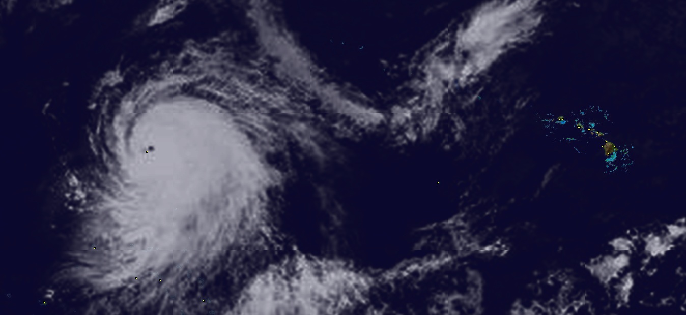
Check out this incredible satellite image taken from Seasonality of Super Typhoon Ioke. Ioke is the strongest typhoon in recorded history to form in the central Pacific Ocean, with sustained winds of 160 mph and gusts up to 185 mph. That yellow dot in the middle of the storm is Wake Island, a territory of the U.S. The storm surge was supposedly going to completely engulf the island, so all 200 people who live there were evacuated and flown out to Hawaii.

It’s rare to see such a large storm with a organized center “eye” like this. Click on the image to get a larger view that shows a reference of where this is taking place. If you are wondering if Hawaii is at risk, don’t, because the storm is heading in the opposite direction. It is projected to weaken to the equivalent of a category 3 hurricane by next Tuesday, still in the middle of the Pacific.

Newer posts »

© 2026 *Coder Blog

Theme by Anders NorenUp ↑